With climate change exacerbating the intensity and frequency of wildfires, new tools are necessary to prepare for them and mitigate their damage.
That damage comes in multiple forms, beyond the wrenching images of devastated forests and destroyed homes. The choking smoke produced by wildfires can travel from one side of the continent to the other, damaging lungs with toxic airborne particulates.
Now, research from the University of Utah’s John and Marcia Price College of Engineering is providing fresh insight into how tall such smoke plumes spread, using a combination of new satellite data to improve models that account for the complex interactions involved.
 Published in the journal Atmospheric Chemistry and Physics, the study was led by Heather A. Holmes, professor in the Department of Chemical Engineering, and Jingting Huang, then a graduate research assistant in her lab.
“We have had great success in improving air quality in the U.S. since the 1970s but smoke from the large wildfires in recent decades has become a major air quality issue and during these events, we have the worst air quality in the world,” says Holmes. “Breathing in wildfire smoke can be as harmful to your lungs as smoking cigarettes and warning vulnerable populations is the best defense we have, so getting a better understanding of smoke behavior is critical.”
Predicting how smoke from a wildfire will spread starts by measuring the height of the initial plume; the higher smoke particles rise, the more they can laterally spread before falling back down to Earth.
“Knowing the height of the smoke plume generated from a fire at the initial stage is important for air quality,” says Huang. “But it’s tough to get right because models and satellites are not always able to capture the small-scale details of the fire and smoke behavior.”
What may seem like a simple measurement can quickly become complicated. Each wildfire is unique in terms of size and strength, but also in the moment-to-moment weather patterns surrounding the blaze, and the topography of the land over which the plume travels.
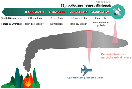
The researchers’ new study details how combining two types of datasets will enable them to develop a statistical data fusion model that can account for such factors. With aerial LIDAR measurements of 2018 wildfires providing plume height data from aircraft flying directly in the smoke plumes, and recently released high-definition satellite smoke plume height datasets providing the plume height information from spaceborne observations, the researchers’ findings illustrate how these spaceborne observations can be used in new models that are more widely applicable to simulating the behavior of wildfire smoke.
In a hypothetical scenario, consider a small town near a forest in a mountainous region. During a particularly dry summer, a wildfire starts in the forest and quickly grows due to strong winds. A better plume model, with accurate smoke height and dispersion predictions, could forecast the path and concentration of smoke reaching the town. Unlike current models, which might give a general idea of the smoke spread, this advanced model would provide detailed hourly updates on smoke levels, factoring in the complex interactions of topography, weather, and fire behavior. This would allow residents to see not only when the smoke will arrive but also how dense it will be and how long it is likely to linger.
By combining satellite data and climate models, local health officials could issue timely advisories for vulnerable populations, such as the elderly, children, and those with respiratory conditions, to stay indoors or evacuate if necessary before the worst smoke conditions arrive.
“The satellite data from this paper can be used in models that improve smoke prediction. Firefighting resources could be more effectively deployed by predicting the fire’s behavior and smoke spread, allowing authorities to prioritize areas at greatest risk,” adds Huang. “Accurate data on smoke plume behaviors and their impact on air quality and climate can even inform more effective land management practices, urban planning, and environmental policies to mitigate the effects of future wildfires.”
-###-
Assessment of smoke plume height products derived from multisource satellite observations using lidar-derived height metrics for wildfires in the western US
Atmospheric Chemistry and Physics
Jingting Huang, S. Marcela Loría-Salazar, Min Deng, Jaehwa Lee, and Heather A. Holmes
https://doi.org/10.5194/acp-24-3673-2024
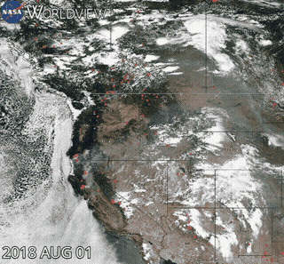
This material is based on work supported, in part, by the NSF Division of Chemical, Bioengineering, Environmental, and Transport Systems (CBET) under grant no. 2048423. Satellite imagery used in GIF courtesy of NASA: Global Imagery Browse Services (GIBS), Worldview Snapshots [data set], https://wvs.earthdata.nasa.gov/ (last access: 15 June 2023), 2018.